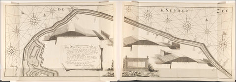
Map of the seawall east of Muiden, 1737, consisting of two parts, Hendrik de Leth, in or after 1737 Canvas Print
Map of the seawall east of Muiden with three profiles of the dike, made after measurements by surveyor Jacob van Hoorn in 1737. In 1735, 1736 and 1737 this dike was reinforced. To the left of the middle a cartouche with the title and explanation. To the right of the middle two scale sticks: Schale of 42 rods Rhynlandz size (for the map); 42 feet Rhynlandz work-but up to ABC (for the profiles).
-
100% Made In America
-
Next Day Shipping Available
-
100% Money Back Guarantee
-
Free Shipping On Orders Of $150+
-
Use Shopify Pay to break the price down into 4 easy payments!
Select Your Size
